
The Escalante Desert Loop
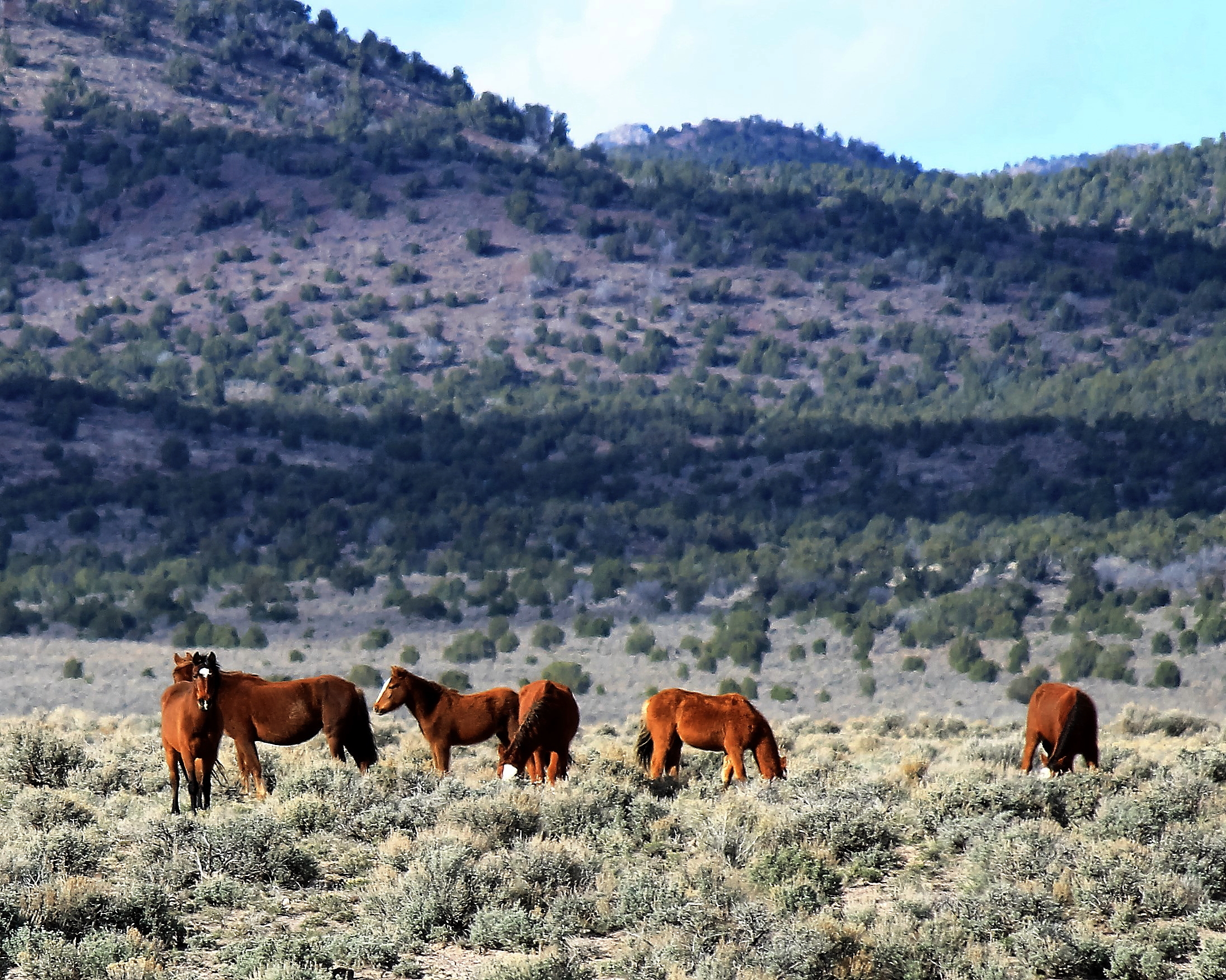
Sage-covered plains. Mountains and hills cloaked in pinyon and juniper woods. Spring-fed oases. Rustic remnants of early settlement. Mustangs, pronghorns, rabbits, ravens, eagles, kestrels, meadowlarks, bluebirds, nutcrackers ... A casual Cedar City day trip promising variety and serenity.
Click here for a printable version of this page.
This 130-mile drive around the Escalante Desert, skirting the borders of six wild horse herd areas, is a modified version of the route traced on this map provided by the BLM's Cedar City field office. Most of this mileage is on unpaved roads, but the route is well-maintained. Four-wheel drive will not be necessary in dry conditions. Try it during the spring or autumn months for the best combination of mustang viewing opportunities and agreeable weather conditions. You should plan on at least three hours actual driving time with no services available at any point along the route, so stock up the cooler and top off the tank before you leave.
Links to the web pages for the herd areas encompassing this tour are included at the bottom of this page (missing links will be activated as more pages become available).


The Complete Tour
From Interstate 15 in Cedar City, take highway UT-56 west 4.5 miles, turning right onto Iron Spring Road – watch for the sign pointing toward the landfill and W.E.C.C.O as the highway veers southwestward. Follow Iron Springs Road 6.7 miles, turning left onto Antelope Road immediately beyond the railroad tracks.
The northern perimeter of Chloride Canyon begins about 6.7 miles down this road, continuing until you pass beneath the power lines 5.8 miles later. Mustangs may be spotted grazing on the slopes south of the road.


Continue along Antelope Road another 11 miles, turning left on the Beryl Highway. Travel 6 miles south to UT-56. Turn right and head northwest 16 miles to Modena. As you drive along this stretch of highway, the North Hills HMA lies to your south; however, the defined border is about seven miles distant, angling northward toward the highway to a point two miles south of Modena. The odds of spotting North Hills mustangs from the highway are minute.
Reaching Modena, you have the option of taking a quick drive through the old railroad town: turn left onto Main Street, just before you reach the overpass spanning the railway. Main Street starts west but curves north after ½ mile, intersecting the highway one mile later and continuing north as Hamblin Valley Road. If you choose to skip the town tour, you’ll want to exit the highway at this location, immediately after the highway turns westward beyond the bridge.


Mt. Elinore rises to your left as you make the short ¾ mile jaunt to 8 Mile Road on your right. This marks the eastern perimeter of the Mt. Elinore HMA.
8 Mile Road begins in a northeasterly direction, shifts more directly northward for a couple of miles, then turns into a long, straight stretch headed northeast. The road forks (1st Fork) just before this turn, about 5.4 miles in from Hamblin Valley Road, so stay on the main road curving to the right. You will be traveling along the southeastern border of the Tilly Creek HMA for the next 13 miles. Be sure to take the left branch when the road forks (2nd Fork) about 2.2 miles beyond this curve. From this point, just stay on the main road and keep an eye on the slopes to your left.

The road veers more easterly about 6.2 miles beyond the last fork. The next 2.8 miles skirts a valley lying between the Tilly Creek and Bible Spring herd areas. As the road bends directly eastward for another 2 miles, you will pass two watering holes within a few hundred feet north of the road, one near either end of this span. Stay to the left when the road forks just beyond the cattle guard about halfway along this stretch.
Follow the road across another cattle guard at the end of this stretch as it begins to turn northward again. At this point, you are approaching the Bible Spring HMA. Continue north 5 miles to the Bible Spring turnoff. The spring is about 1.2 miles down this side road, and worth the short side trip for the chance of spotting horses at or near the pond. Returning from Bible Spring to the main road, turn left and follow as it turns eastward and forks (3rd Fork) 2.4 miles later.


As you pass through this last fork, taking the right hand route toward Mountain Spring Road, the Four Mile HMA begins to your left. Remain on Mountain Spring Road until you reach the old Lund railroad depot 12.1 miles later. You’ll pass three watering holes on this stretch. The first is about 120 yards north of the road, about 4.8 miles from the last fork. The other two lie about ½ mile south of the road, each about 1.5 mile further down the road than the last.
Having arrived in Lund, you’ll make your way back to Cedar City via the Lund Highway, ¼ mile to your left. Follow the Lund Highway 30.5 miles to rejoin UT-56, then turn left and continue into town.


Key GPS Coordinates
Iron Springs Rd from UT-56: 37° 41.091' N113° 9.723' W
Antelope Rd from Iron Springs Rd: 37° 45.165' N113° 14.548' W
Beryl Hwy from Antelope Rd: 37° 47.676' N113° 39.366' W
UT-56 from Beryl Hwy: 37° 42.575' N113° 39.370' W
Main Street, Modena from UT-56: 37° 47.926' N113° 54.689' W
Hamblin Valley Rd from UT-56/Modena: 37° 48.152' N113° 55.551' W
8 Mile Rd from Hamblin Valley Rd: 37° 48.770' N113° 55.803' W
1st Fork: 37° 52.782' N113° 53.387' W
2nd Fork: 37° 53.881' N113° 51.466' W
Tilly Creek roadside watering hole: 37° 57.319' N113° 42.359' W
Bible Spring roadside watering hole 2: 37° 57.336' N113° 40.719' W
Bible Spring Turnoff: 38° 1.152' N113° 39.133' W
Bible Spring: 38° 1.765' N113° 39.941' W
3rd Fork: 38° 2.551' N113° 37.873' W
Four Mile watering hole #1: 38° 0.697' N113° 33.678' W
Four Mile watering hole #2: 37° 59.651' N113° 32.170' W
Four Mile watering hole #3: 37° 59.438' N113° 30.552' W
Main Street, Lund: 38° 0.351' N113° 26.049' W
Lund Hwy from Main St, Lund: 38° 0.451' N113° 25.912' W
UT-56 from Lund Hwy: 37° 41.112' N113° 6.667' W
Herd Areas Included in this Tour
Mt.Elinore